previous day
Day 4 - Good Friday
I did not sleep well despite the luxury of a bed. I lay awake listening to the rain drumming
on the skylight and wondering if I could survive if I had to camp in these conditions with
the tent already sodden. Although this hostel is on a main road it is nowhere near any other
accommodation or shops. I wondered if I should just sit all day in the wet weather shelter
and return to the hostel tonight. The waning moon shone through the skylight but its
promise was shortlived as I woke and realised that the moon had been only a dream.
At five to seven I managed to tune my little radio in to the forecast and heard the
welcome prediction of brighter weather in the afternoon. I hoped that it would come early
like yesterday's rain. Already, although the rain was beating down heavier than ever, there
were signs of improvement for the ridge of Y Gyrn, my first hill today, could actually be
seen from the hostel window.
I postponed my departure right up to 10am when hostellers are thrown out whatever the
weather. I asked the warden if there were beds available tonight should I come back and the
answer was 'no' so the die was cast.
I set out in all the waterproofs. I had managed to squeeze my socks into the drying room
and it had worked to some extent for they were now only damp rather than dripping. The
mist was swirling over the hills again but as I climbed onto the ridge it cleared and the rain
stopped. I remembered that when we were collecting the two-thousanders from George
Bridge's tables this had been Rowland's last top. Then we thought it a dreary hill to finish
on but today it was magic. I could actually see something! I photographed the hills to the
west which I had traversed over the last two days without seeing them. Then I
photographed the dramatic silhouettes of Corn Du and Pen y Fan ahead. A few minutes
later they disappeared again in mist.
I walked up to the memorial stone to Tommy Jones, surely the most poignant monument
on the British hills. The place is haunted by the thought of this five year old dying here
alone but I suppose without the stone as a reminder few would feel the ghosts. I thought as
well of the two toddlers who had died recently in tragic circumstances, James Bulger, lured
away from a shopping centre and tortured to death, and Jonathan Ball, blown up by the
IRA. Then a group of noisy young walkers came up the hill scattering my morbid
reflections.
 I continued up the wide, red, eroded track to the summit of Corn Du. It had been
pitched in places. It is not surprising I suppose that the path along the ridge of the Brecon
Beacons is so badly eroded. Here was I adding to the erosion by walking the obvious path
along the edge of the dramatic northern escarpment. I was walking it in company with
crowds of other people. This end of the ridge in particular is temptingly accessible from the
high road pass at Storey Arms and it was rather horrifying to see how ill-equipped many of
the parties seemed to be, some with no rucksacks or spare clothing whatsoever and others
with one tiny pack between a large group of people. It was by no means a warm, set fair sort
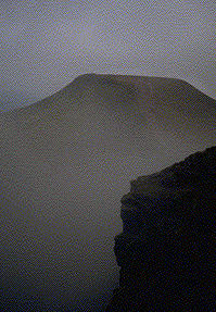
of day. On the contrary the weather was amazingly volatile. Pen y Fan soared up out of the
mist ahead, posing for a dramatic photograph. By the time I had covered the short distance
to this the highest top of the Brecon Beacons it was in thick mist again.
I continued up the wide, red, eroded track to the summit of Corn Du. It had been
pitched in places. It is not surprising I suppose that the path along the ridge of the Brecon
Beacons is so badly eroded. Here was I adding to the erosion by walking the obvious path
along the edge of the dramatic northern escarpment. I was walking it in company with
crowds of other people. This end of the ridge in particular is temptingly accessible from the
high road pass at Storey Arms and it was rather horrifying to see how ill-equipped many of
the parties seemed to be, some with no rucksacks or spare clothing whatsoever and others
with one tiny pack between a large group of people. It was by no means a warm, set fair sort
of day. On the contrary the weather was amazingly volatile. Pen y Fan soared up out of the
mist ahead, posing for a dramatic photograph. By the time I had covered the short distance
to this the highest top of the Brecon Beacons it was in thick mist again.
The path down on the east is even more eroded. There are those now who talk of permits
and quotas on the hills as if somebody has the right to ration access to beauty. 'The Lake
District is being loved to death' somebody said and no doubt the same will be said of the
Brecon Beacons and Snowdonia and eventually the Munros. It is rubbish really for
unsightly though these eroded tracks may be they are mere scratches on the surface of the
mountains. Not until I reached Ffestiniog was I to see deep wounds inflicted on the very
structure of some of the hills.
I used to be very antagonistic to any work on footpaths in the
high mountains. I felt that paths should just be allowed to get more and more eroded and
that those who wanted to climb the hills were causing the trouble and should put up with it.
I have come to see recently that this is perhaps hypocritical because I have been very happy
in Scotland to use made stalkers' paths which often run high onto the ridges. I am a
voluntary warden for the Lake District National Park where the state of paths is always a
topical issue. Neil Allinson of the National Trust came to talk to us about the work which
they were doing high on Scafell. 'I love the mountains' were his opening words, a phrase
guaranteed to give him a sympathetic hearing! I am beginning to be convinced that some
path improvements can enhance the environment even on the high mountains. Some ghastly
mistakes have been made though, creating paths which would seem more at home in an
urban park or, even worse, roads more suitable for landrovers than walkers.
 The climb onto Cribyn was just as long, steep and eroded as it looked on the way down
to the col. At the top I met a young couple putting on extra sweaters. 'Its breezy up here' I
greeted them. 'Yes its a dreadful day' he replied. I was so astounded by this remark that I
made no response. I thought it was a marvellous day. True the mist had come down again
but not for long. A few moments later it was torn apart once more to reveal spectacular
glimpses of a landscape far more exciting than would appear in unbroken sunshine. I
certainly should have said 'a lot better than yesterday'.
The climb onto Cribyn was just as long, steep and eroded as it looked on the way down
to the col. At the top I met a young couple putting on extra sweaters. 'Its breezy up here' I
greeted them. 'Yes its a dreadful day' he replied. I was so astounded by this remark that I
made no response. I thought it was a marvellous day. True the mist had come down again
but not for long. A few moments later it was torn apart once more to reveal spectacular
glimpses of a landscape far more exciting than would appear in unbroken sunshine. I
certainly should have said 'a lot better than yesterday'.
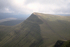
The ascent to Fan y Big was more or less a twin of the one up Cribyn, just as steep but
more mud and grass than stones. The top is a spectacular wedge of rock, like the prow of a
ship set on a northerly course it protrudes from the line of the escarpment and gives
wonderful views back along the ridge westwards to the highest summits round which the
mist was swirling and lifting even as I stood there trying to catch this dynamic scene in the
camera.
I could see also the less dramatic but equally beautiful sweep of ridge eastwards which I
was to follow next. It runs amazingly flat topped in a great arc for about two miles before
the escarpment finally disappears in the grassy slopes of Waun Rydd. I had no sooner
embarked on this section than thick mist came down again. The long line of the hill shrank
to the span of a few paces and the steep edge on my left was sensed rather than seen as the
ground curved sharply downwards into a uniform grey emptiness. There were fewer people
about now as the highest and most spectacular hills were left behind. I felt privileged to be
doing the whole ridge in this way without the need to return to a vehicle.
A pile of stones covered with blue tarpaulin was obviously intended as an emergency
shelter. Inevitably the area around it was polluted with piles of rotting litter. The next hill
in the list lies at the far end of the escarpment, an ill-defined top with the misnomer of
Bwlch y Ddwyallt.
Waun Rydd feels a very different hill. It has two cairns and the path does not bother to
go to the more northerly which is supposed to be the higher. The top is just a plateau of
grass and bog and although the mist cleared I felt that the summit could have been almost
anywhere. After reaching the southern cairn I still had to walk quite a long way across this
flat terrain on a compass bearing to find the narrow ridge which leads down to the final
summit of the Brecon Beacons traverse, Allt Lwyd. This ridge could have been quite tricky
to find if the mist had not cleared. Instead it was tricky because of a strong wind which had
unexpectedly blown up. It was now quite clear but the views of the main ridge were lost on
this southern outlier. Most striking now was the view eastwards across Talybont Reservoir
with Tor y Foel behind it and the Black Mountains looking a long way off beyond.
I dropped down to the Nant Cynafon and, with some difficulty, found a campsite on its
banks. I felt well satisfied with what had started out as a very unpromising day.
next day
Across the Dragon's Back index . . . . . . Welsh Marilyn index . . . . . .  my homepage
. . . . . .
my homepage
. . . . . .  GeoCities Yosemite