 Get your own Free Home Page
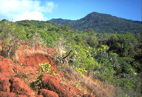 The island of Mayotte (known locally as Maore) in the Comores is politically a part of France and hence has its own long distance footpath or Grande Randonnée, the GR MT. On our short visit we had time only to walk two segments of this route, the one from Mamoudzou to the north coast where we were staying and the one between Bandrele and Dembeni which traverses Bénara the highest summit on the island. The route is waymarked although we had been warned that we might get lost on the descent.
The path climbs across fairly open and eroded terrain as shown in the picture. Beyond this point it enters thick jungle. Although it was broad daylight the way was in deep shade and the mosquitos were awful. I pulled on a pair of long light trousers and suffered the discomfort of excessive heat in an unsuccessful attempt to avoid being bitten. The way grew steeper, clambering up near vertical steps on tangled tree roots. Chattering and rustling drew our attention to a band of lemurs in the branches high above our heads.
We reached the unmarked south top, which looks the highest in the picture, and from here embarked on the sensational traverse of a knife edge ridge reminiscent of the Crib Goch ridge in Snowdonia. In places there were quite awkward steps over tree roots or enormous boulders yet there was little sense of exposure since we were still surrounded by trees. Several times we thought it impossible to proceed but managed to circumvent the difficulty and eventually arrived at the large trig point and tiny clearing at the top. Despite the overgrown nature of the trail there was plenty of evidence that this summit is quite often visited.
We decided to risk the continuation northwards despite the warning from the tourist office that we might get lost. It was in fact straightforward and clearly marked except at one point where, in the vicinity of a shelter, the waymarks disappeared and it took several false starts to pick them up again.
Although Bénara may not really rank amongst the notable mountains of the world it was certainly one to remember, the knife edge in the jungle being totally unique in my experience.
. . . but I have failed to find any reference at all to the mountain. If anybody can give me such a link or has climbed the mountain please let me know.
 Walking the World Index
Get your own Free Home Page
Walking the World Index
Get your own Free Home Page