We had been gaining on the other party but beyond this first summit they mysteriously disappeared. Instead we encountered a single foreign female who sought our advice. She carried a guidebook containing a route called 'Doune Hill' accompanied by a portion of the OS map. We pointed out Doune Hill and also showed her where on the map we were although she seemed reluctant to believe us. She was confused by the lack of a path, the faint one which had led up to the first summit having now petered out in a maze of sheep tracks.
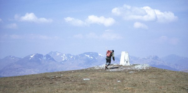
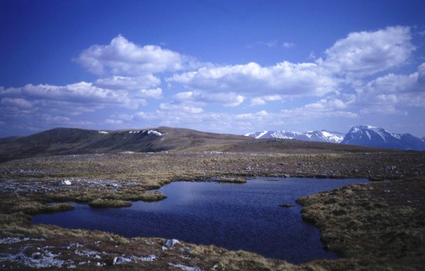
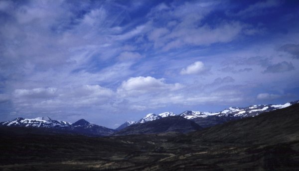
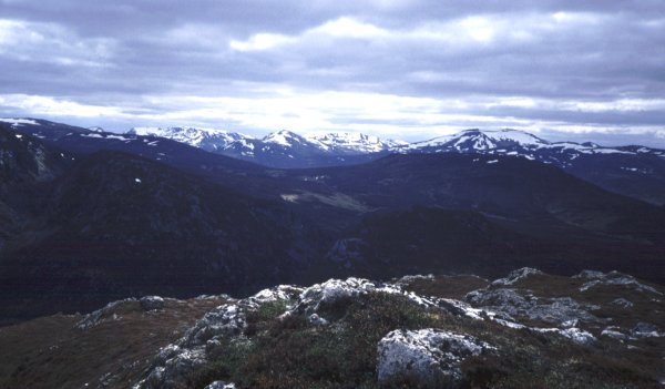
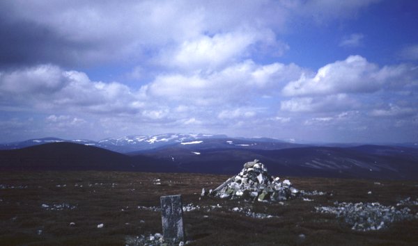
It seems that she decided to return the same way while we pressed on to the top of Doune Hill, the highest of this wedge of hills west of Loch Lomond which we were gradually picking off on our journeys to the Highlands. There is a little summit plateau with the trig point right on the western side. We were blown across to it and embraced it to stop being swept off the hill while enjoying the views westwards to the Arrochar Alps [picture] and the white queen Cnoc Coinnich which we had climbed at Christmas, now with only the slightest streak of silver in her hair.
Cruach an t-Sidhein is the penalty for the peak-bagger, a little outlier with a profile reminiscent of Great Gable. We cut back to the col and up steepening slopes to the summit which was fortunately far less windswept than its higher neighbours. We could see a good line of descent south-eastwards but the very steep slopes at the top meant that we had to set out in exactly the opposite direction to reach the fence which we could then follow round the hill to the easy slopes below.
Rowland dropped me out of the motor caravan down by the shore so that I could put a toe in the Atlantic although the very enclosed waters of Loch Ailort were scarcely recognizable as the sea. Soon I was setting out with several other groups of walkers and chatting as we climbed up beside the Allt na Criche in the sunshine, never guessing that it would shine with hardly a break until we reached the North Sea.
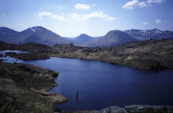
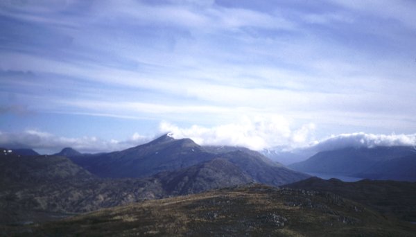
I left the track, crossed the stream and went up onto the slopes of Glas-charn. Within five minutes I was out of sight of the path in a landscape as wild and empty as any in Scotland. The ridge was rough indeed. Few walkers come this way but a fisherman, with his dog, was casting in a lonely lochan [picture]. I passed by quietly, unnoticed, feeling a certain rapport with another lover of these secret silent places.
A broken fence could be followed almost to the top but it takes a very bizarre course and definitely does not avoid the boggy bits of which there are plenty. The craggy summit was marked by a tiny cairn. Already the sea looked far away westwards with the unmistakeable profile of Eigg particularly prominent [picture] and the Isle of Rum fading into the haze of this gloriously hot afternoon. At the summit also was a small B made of stones. This was the sign that Rowland had been there before me, having come up and down by the much shorter route from the east which I now followed down to the road and to beer in the Stage House Hotel.
There was no B at the top. Our system was simple. If I found a B, I destroyed it, if not I built one. Although this was obviously not infallible, most of these lower hills are seldom climbed so it seemed unlikely that the message would be destroyed. Since Rowland did not in fact climb Aodann Chleireig on the trip it will be interesting to see if the B survives until he does. The descent was diabolically steep. The main ridge runs east to west. The subsidiary one northwards lies right on the join of two maps and neither gives any clue to the crags on this side of the hill. There were big patches of snow too. At one point I had to resort to sitting down and edging my way gingerly down the steep and slippery grass between two crags, a hazardous procedure made even more awkward by the big rucksack.
Meall Onfhaidh is a far more straightforward hill. Its south-west ridge is very similar to the nearby south-west ridge of Gulvain, being very steep and grassy but requiring only 1000 instead of 2500 feet of ascent.
I sat down at the summit and gazed round the whole magnificent panorama, thinking of the 250 people making their way across the Western Highlands. Here I was enjoying total solitude. It was one of those moments, experienced only in the mountains, when the silence suddenly assaults the ear as powerfully as an explosion and one catches one's breathe, and stops, and listens to the quietness of the hills. [looking back towards Aodann Chleireig]
I moved on reluctantly, down to Glensuileag bothy where I met a couple of Challengers just packing up to move on. It was so hot and sunny that it was quite a relief to spend half an hour inside for lunch and a brew up.
The bothy lies on the 170m contour line which meant that I had nearly 2000 feet of ascent to my third and highest summit of the day, Druim Fada. I watched the other party disappear towards Glen Loy and thought ruefully that I was supposed to be doing a low level traverse. A high level one requires the ascent of a dozen or more Munros or Corbetts. These little Grahams do not count as mountains. Glen Loy was my foul weather alternative route but the weather was not foul, it was superb. There was no possible excuse. I shouldered the pack, crossed the river easily in these dry conditions and dog-legged eastwards to get onto the ill-defined and painfully steep north ridge.
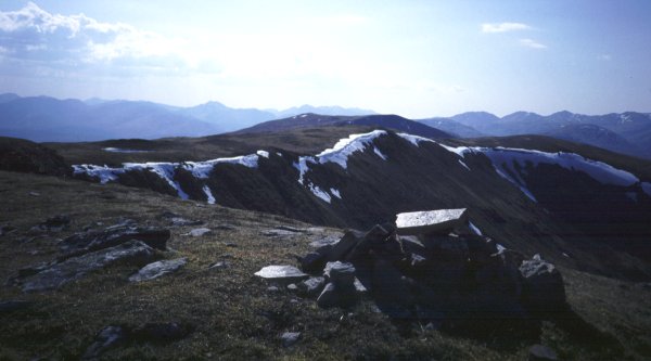
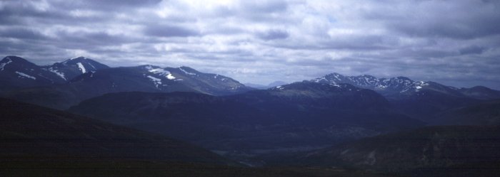
On the flat ridge above the effort was soon forgotten, replaced by delight. There can be few more splendid places than this for making rapid west to east progress across Scotland. The going is smooth, firm and dry. The gradients are easy. The views are magnificent, especially for the eastbound walker who is stepping ever closer to the great snowy giants, Ben Nevis, the Aonachs and the Grey Corries [picture]. The hazy silhouettes of early morning were replaced now by crystal clarity with every crag and cornice sharply illuminated in brilliant sunshine.
I met a couple walking west, the only walkers I saw on any of my ten two-thousanders, except for one planned rendezvous. I knew that there would be no message for me on this one, for Rowland had climbed it long ago and had told me what a splendid ridge it was. [looking back westwards from the summit]
The descent at the eastern end was no more pleasant than the ascent at the west, the penalty one pays for a peaceful hill perhaps. The Corpach Hotel was the first place I came to. It offered bath, beer, bed and breakfast which I enjoyed in that order. There was dinner too but I was almost too tired to eat it.
I put the camera in one pocket, my scrap of map in the other and set off up the hill with no other equipment whatsoever. A fox stopped for a long look at the intruder before loping off into a jumble of boulders. In half an hour I was at the summit, an attractive coxcomb of rock sheltering a tiny lochan. Beside the small cairn was Rowland's B.
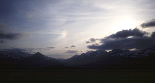
The whole traverse across Scotland turned out to be one delight after another but this glorious evening was perhaps the moment which will linger longest in my memory. The distinctive craggy Corbett, Sgurr Innse, and its higher neighbour Cruach Innse peeped out behind the sweeping snowy ridge of Stob Coire Easain. Loch Treig lay almost vertically below while southwards Buachaille Etive Mor was particularly striking and the Aonach Eagach was seen in perfect silhouette. Yet it was the view westwards which drew my gaze as the sun sank behind a low line of cloud, illuminating Ben Nevis and, most beautiful of all, Binnein Mor, totally white except for two stark black ridges in perfect symmetry. [picture]
(Creag Guanach next morning [from Loch Treig] [in silhouette with the Mamores and Ben Nevis behind])
For a moment I was in doubt about the summit for a lower top bore a cairn while that at the highest point, confirmed by the position of a small lochan, had been destroyed. I rebuilt it together with a B, and once again it will be interesting to see if it survives until Rowland climbs this hill.
(views from Beinn na Cloiche looking [north] [west] [south])
I descended eastwards, then back north to Loch Treig, round to Loch Ossian and up the Uisge Labhair. A strong east wind made it seem unwise to cross the bealach so I pitched the tent on the western side beside a fireplace which had presumably once been part of a building.
After a chat I pressed on past Loch Pattack and up the Allt Beinn Eilde, a stream so tiny that I practically sat astride it for a midday brew up. As I continued up the path the hill for which this stream is named looked down reproachfully on my left hand side. According to my map, admittedly an old one, its height is 673m while the spot height on the col is 525m and it seemed to be saying ,"its a lovely afternoon and yet for the sake of two measly metres you are passing me by". At a small cairn, which seemed of no particular significance, I suddenly heeded it and went straight up. It greeted my arrival on the ridge with a sudden burst of sunshine but by the time I reached the top it was spitting snow again. From the summit I could see my next listed two-thousander and the beautiful lochan which lies below it.
Lochan na Doire-Uaine is one of those places that one hesitates to write about, lest people should go there and spoil its fragile beauty. Fortunately its remoteness, both from the road and from any Munro, makes it unlikely that it will ever become a popular destination. The easy way up the hill would have been to plod up the heather either over or north of its subsidiary west top. However the narrow eastern end of the lochan looked too good to miss so I went that way and through the bealach behind, no easy task as it was choked with huge boulders swathed in luxurious vegetation, a place where one had the feeling of treading where none had trod before and of course a place where a lone walker had to take particular care.
Eventually I made my way through to the col between Meall nan Eagan and its craggy little west top, where a line of cables marches incongruously across this untamed landscape. After my exciting approach the summit was a bit of an anticlimax and not a place to linger in the bitterly cold east wind. [the view west] I constructed a B, which Rowland found and destroyed two days later, and then made my way down the steep east ridge, encouraged by a broken fence. I knew that the path shown on my old copy of the map had disappeared on the new one so it was only mildly disappointing to find the going rather unpleasant. Rowland later reported that a track runs up the Allt an t-Sluic almost to the bottom of the south ridge so that is obviously a pleasanter approach. I spent the night in Dalwhinnie where I was lucky to get a bed in the transport cafe.
Nearby was Meall Cuaich, one of the easiest Munros and perhaps one of the least memorable for many people. Yet on this hill, many years ago, happened one of those moments which linger in the mind for ever. I have spent hours and hours wandering in the hills, long hours of just enjoying and soaking in the atmosphere of the Highlands so that it penetrates one's innermost being. Among these distant hazy memories, this blur of hills and happiness, there are a few moments which stand out with the utmost clarity like sharp cut diamonds set in a crown of gold.
We stopped in a blizzard, crouching amongst some rocks to put on the crampons. A ptarmigan flew out and in an instant was swept away in the storm. That one simple superb flight stays with me still to symbolise the beauty and the wildness of the mountains.
I left the summit shelter with regret for this was the last of a natural line of two-thousanders and the next lay two days away beyond the forests of Speyside. I was almost down to the valley when I realized that I should have danced a jig or opened a bottle of champagne on Creag Ruadh summit for it was my number 112, the halfway point of the Grahams [summit cairn].
The banks of Water of Caiplich gave quite easy going with the occasional scramble round a rocky corner. I saw one single human footprint and later, on the summit of Mount Keen, I met the Challenger who had probably left it there. The river suddenly turns a dramatic corner and runs into a spectacular gorge. Here I went straight on, up steep heather onto Carn na Ruabraich [picture] and thus to the next two-thousander Cnap Chaochain Aitinn [picture]. Rowland was just arriving at the very grassy summit for the second time, carrying up a handful of stones for a B. He had come up first just five minutes earlier, a remarkable piece of coordination for a rendezvous arranged so long before.
We descended along the long south ridge with stunning views of Ben Avon, its tors protruding through vast snowfields. In Glen Loin we stopped for lunch and a brew up and a bathing of tired feet in the river. While we were enjoying this rest the estate manager drove up and told us that we had no right to be there. He said that we should have asked permission to climb Cnap Chaochain Aitinn but added that had we done so the answer would have been 'no'. The only possible reply to this seemed to be 'then I'm glad I didn't ask' but I desisted from this response and the encounter ended amicably.
Long before we acquired Dawson's tables Rowland had compiled a list of 'interesting lower hills' culled from the SMC guides. Within this list he had ticked Mona Gowan but my column remained blank. I had such a clear recollection of adding this hill to the ascent of the Corbett Morven that I ascribed this omission to clerical error and had claimed the hill anyway. Now that tiny lingering shadow of doubt was sending me onto this ridge which lay almost on my route anyway. I was indeed grateful for the clerical error for it was far too fine a day to stay in the valleys.
These rolling ridges cannot compare with the craggy hills of the west I thought as I climbed up onto Scraulac [picture] and yet, as I wandered along to the enormous cairn on Mona Gowan [picture] and over all the bumps of its long south ridge, the day was just so splendid that I could not possibly have wished to be elsewhere. White bubbly clouds floated in a blue sky. The snowy peaks now left far behind were backdrop to a foreground of sweeping heathery moor, the whole scene conveying a wonderful spaciousness and emptiness which made one want to shout with delight. [Morven from the ridge of Mona Gowan]
This incredible weather continued next day, for the traverse of Mount Keen, but my mood was more sombre for I had heard in Ballater that Fiona Graham's body had been found and because I had been climbing her hills I felt a particular sadness that she would no longer enjoy their beauty. Indeed appreciation of this beauty is often touched by sadness, an awareness of time passing and an underlying ache that one may not linger here forever.
On the penultimate day, which turned out to be one of the finest of the whole traverse, I went over the Corbett, Mount Battock, and 'discovered' the splendid Clachnaben, capped with a rocky tor, which is not in any tables.
I incorporated one final hill into the traverse, Kerloch, which does appear in Dawson's tables and is the most easterly hill above 500m in the Highlands. From the summit I saw the early morning sun glinting on the sea and I knew that my lovely journey was nearly over.
After a bit of confusion with new bulldozing we found the well established track which took us high onto the south ridge of Meall a'Mhuic. Thereafter it was a simple tramp through improving going as the heather became shorter and shorter with increasing altitude. As I tramped I was considering what I might write about this hill and the phrase 'easy but uninteresting' came to mind. Well 'easy' it certainly was and 'uninteresting' too if one was looking for dramatic ridges, cliffs or crags. Yet there was a real surprise which made this a hill well worth climbing. It lies on a wedge of ground with a Corbett on either side and behind each Corbett some Munros, a situation which had led me to suppose that the view would be a very restricted one. It was quite a surprise therefore to find that it gave a splendid aspect southwards of Ben Lawers and its satellites [picture], an amazing distant panorama of snowy mountains northwards and a totally unexpected end on glimpse of Glencoe to the west. Only the cold east wind, which had been blowing now for two weeks and keeping the bad weather down in England, stopped us from lingering for a long time at the summit. We dropped down north-eastwards to join the right of way through the Lairig Chalbhath for the return to the picnic site after a very easy but unexpectedly rewarding short walk.
 my homepage